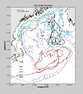
Drifting Buoys, RMRP 1994
Drifting Buoy Information:
Five satellite tracked drifting buoys were deployed on 29 April 1994 by the RV Argo Maine.
Two were drogued at a 10 meter depth (22502 and 22503) and the remaining three
had drogues at 40 meter depth. The drifting buoys transmitted via Service Argos
and between 4 and 8 positions were received daily for most of the buoys. The
table below lists the deployment positions along with the date and position of
the last transmission.
Data Processing:
The positions calculated by Service Argos were edited using a default speed
criterion of 6 knots, eliminating unrealistic positons. The cleaned time series
were fit by a cubic spline and interpolated to hourly positions. The hourly
positions were low-pass filtered to remove any tidal effects.
Data Display:
The smoothed position time series are shown for each buoy. The symbols on the
plots are every seven days, starting from 02 May 1994 at 0000z. Labels indicating
the date are placed every four weeks.
| PTT | Drogue Depth | Date Deployed | Latitude | Longitude | Last Date | Latitude | Longitude |
| 22502 | 10 m | 29 April 1994 | 44° 16.09´N | 67° 22.22´W | 04 Nov 1994 | 39° 37.14´N | 71° 07.26´W |
| 22503 | 10 m | 29 April 1994 | 44° 28.13´N | 67° 16.76´W | 28 Jul 1994 | 41° 45.36´N | 70° 25.68´W |
| 22504 | 40 m | 29 April 1994 | 43° 56.98´N | 67° 29.96´W | 09 Jul 1994 | 41° 16.02´N | 68° 59.10´W |
| 22505 | 40 m | 29 April 1994 | 43° 33.45´N | 67° 39.95´W | 06 Nov 1994 | 42° 36.48´N | 70° 10.92´W |
| 22506 | 40 m | 29 April 1994 | 44° 16.09´N | 67° 22.22´W | 11 Sep 1994 | 43° 29.52´N | 68° 32.04´W |
